Having secured voter approval for increased building heights across the core of the 28-acre site, the preparation of the Environmental Impact Report for Forest City’s Pier 70 project and an additional 7 acres along Illinois Street, adjacent to Irish Hill, is about to get underway.
And depending upon whether the development team decides to maximize the Central Waterfront site for residential or commercial use, the Pier 70 Project will now include between 1,645 and 3,025 residential units; between 1.1 and 2.3 million square feet of commercial/office space; and up to 519,000 square feet of space for retail, light industrial and arts uses along with 3,300 parking spaces and nine acres of open space.
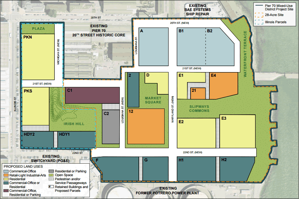
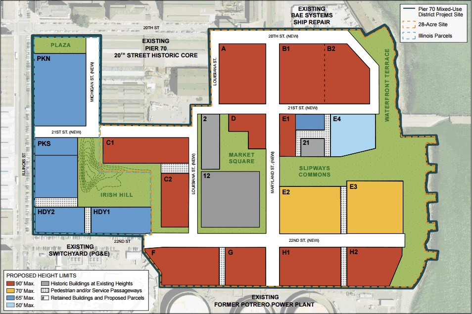
New buildings on the site will range in height from 50 to 90 feet. And assuming all necessary approvals and no major delays, construction is now expected to begin in 2018 and be phased though 2029.
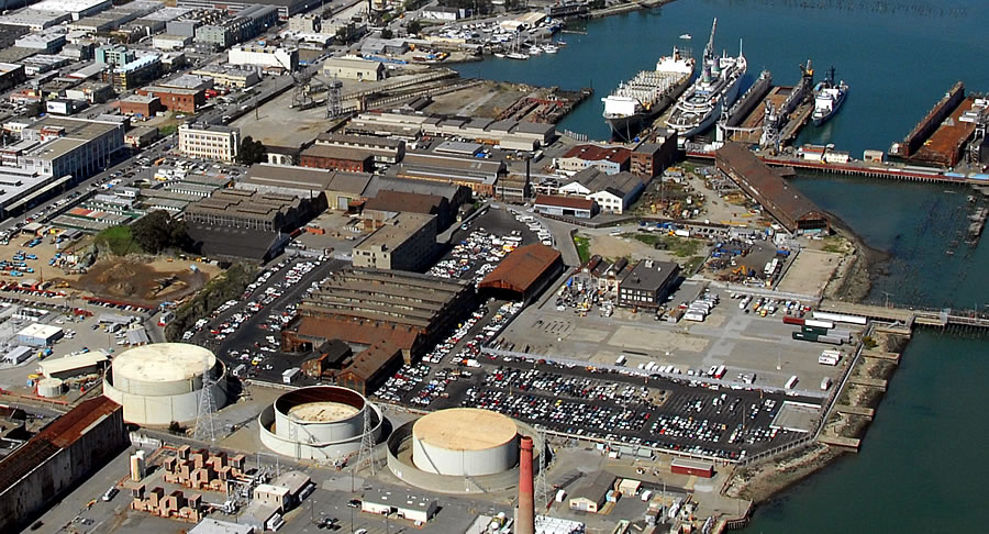
The redevelopment of Pier 70’s Historic Core, a separate six acre project, is already underway.
sigh …begin in 2018 and be phased though 2029 – that’s asking to a big moving delay of a target. Can’t come soon enough.
Yup, and with at least one economic downturn, and possibly two, during that period, it’ll be more like 2015 through 2035… at that rate, maybe some of the residents will live to see a 2nd transbay tube… sigh
sigh kiss all of the “real” work SF was based on and embrace the new Developers Manhatten. Manhattanizations is not all about height.. But oh well — que the” it shold be higer and denser” contingent.
The “real work” of the industrial port is already gone. That ship has sailed (literally and figuratively). This is just reclaiming unused land.
Which raises an interesting question which has always intrigued me. Why did San Francisco develop into a large city and major port as opposed to something more akin to Sausalito? A harbor age with convenient and quick access to the sea supporting fishing as opposed to commerce.
When you think of it, makes no sense to sail across thousands of miles of ocean only to put into Yerba Buena Cove. Might as well land on an offshore island. Everything and everyone would just have to be reloaded aboard a vessel to sail the few additional miles to complete the voyage to the mainland.
My theory is that the Bay was too shallow for ships of the day to cross it or today Oakland would be the center of the Bay Area and the major port it became as a result of dredging operations that have to be continued to this date. Yerba Buena would have remained a quaint village on the shore of an incredibly beautiful and desolate peninsula putting even Point Reyes to shame.
Anyone know the actual historic explanation?
Yerba Buena Cove, which was directly below Telegraph Hill, was the deepest anchorage closest to the mouth of the Golden Gate within the protection of the bay. Offshore is too rough, Oakland too shallow. It was simply the best harbor. Then the gold rush happened and San Francisco (Yerba Buena) was the lucky recipient.
This. Both Richardson Bay (Sausalito) and the East Bay were essentially mudflats… but by Orland’s same logic, I’ve always wondered why ships didn’t simply continue on to Benecia / Vallejo – that way you’re on the mainland and much closer to the gold of the Sierras.
San Francisco was a key coastal military garrison from the early days until after WWII because it commands the Golden Gate from the Presidio. Whatever meager army was around was based in the Presidio and Ft Mason from the Spanish times on. It is also why the Presidio extends from the gun emplacement at Ft Point all the way south to the ridge line overlooking Richmond centered at the golf course. Checkout the view from the old hospital that has been converted into apts.
SF was/is the mainland. You can follow the El Camino Real all the way from the Embarcadero at Mission St to Mexico City. Most of the population of CA has always been on or near the coast and more or less along the El Camino. Also, SF port was always adequate for ocean going ships and to get to/from Sacramento required changing to shallow draft, so someplace in the bay had to become a major ocean port.
So you have the army and an international shipping port, may as well put the mint there and then the banks, and besides there weren’t many people in CA for a long time. As late as the 1906 quake, SF had about 20% of the total population of CA. SF was nearly an ideal size for the pre-car era, ~30 minute trolley ride from bay to ocean, and then Henry Ford, LA oil fields, autosprawl CA style.
FWIW, Oakland has no advantage as a transshipment port except for having a shorter railroad link inland and that only reached a tipping point when the efficiency of containerized shipping made being a little closer to the inland rail net more valuable and then SF port finally threw in the towel when they refused to increase the height of a rail tunnel to allow doublestacked trains to pass. And now it is doing it’s best to remake the port of San Francisco into an amusement park.
For the record, the port of SF still does handle cargo (around 1-2 million tons per year, last I checked), and has container terminals (south of pier 70). There’s even the occasional freight train that stops by. It’s a small amount of action compared to the port of Oakland, but people seem to forget it happens at all. SF also has one of the largest dry docks on the west coast…the port isn’t all an “amusement park”. Though I guess one day it might be.
Thanks for the background Jake. The military component is a non-trivial issue back when SF/YB was a remote outpost. And the tip of a peninsula is easier to defend than Oakland’s site.
Would you rather want Embarcadero to remain a container port? I am quite happy that Oakland took the business, the pollution, and the truck traffic away. Now I can enjoy my “amusement park” with gorgeous waterfront view 🙂
@Sierrajeff Yes, in stark contrast between the situation here and Astoria, OR (mouth of the Columbia R.) and Portland. Ships continued sailing as long as the river was navigable. I suspect that, in addition to the bay mudflats, there initially was no way for ocean-going ships to continue on the the Delta/river systems to more easily and quickly get to the gold fields.
Thanks for the excellent recounting of what did, in fact, develop from the days of founding. However, I’m convinced it all relates back to the fact that the east shore was not initially reachable by ships without very shallow drafts. Had it been, El Camino Real would certainly have been built but it would have followed the course of present day I-880 with a likely spur up the peninsula to outfit the military fortification which surely would have been built at the Golden Gate. The main urban center would have grown up around Oakland where those mints, banks, etc. would have been located. I doubt that very much would have been built where we all now happily reside. Even with San Francisco here, look how rural and undeveloped coastal San Mateo Co. and West Marin remain.
Not that I’m complaining. I love SF but it must have been a very beautiful place in its natural state commanding a wild, windswept cape with ragged shoreline, natural springs and rivers with fauna abounding along with what were the most expansive sand dunes on the West Coast. I’d love to pay it a visit. Somebody must have done a collection of artist’s illustrations or even a flyover video depicting 18th Century SF. Anyone know of such a resource?
I have to disagree with you about the relative competitiveness between Oakland and SF as deepwater ports. Once dredging operations made the East Bay accessible, there was no point to shipping to the Embarcadero other than the fact that, by then, it had already been developed and was in operation. Even before the intermodal ground transportation and container ships finished the job, trans-shipping nearly everything that arrived across the Bay or around the Peninsula through a dense urban environment made little sense.
I’m all for turning the Port of SF into an “amusement park.” Maintaining the port is a sentimental absurdity. It should sell off its holdings, pay off its debt and go out of operation. The Tourism Bureau can take over its function since no ship entering the Gate has any business stopping in SF unless it is a cruise ship.
The land the Port controls is way too valuable with astounding potential to be wasted on so-called “maritime purposes.” Please, open it up to more useful purposes such as residential (can you imagine what kind of neighborhood could be made of the remaining finger piers), hotels and recreation.
The Benica/Vallejo port was the main alternative to SF for ocean going ships during the Gold Rush. Mare Island was even selected as the first US Navy base on the west coast in the 1850s. Landing there instead of SF would save less than a day on a multi-month trip for the 49ers.
When the Gold Rush happened SF already had a larger population, a working port, the US Customs House was there so international cargo had to go there for clearance. Until the transcontinental railroad was completed after the Civil War, SF was more connected by trade with the pacific coast of latin america than the US east coast and midwest.
And the SF city fathers took advantage of their lead both to do whatever it took to make the port work and to undercut Benicia politically (not granted port-of-entry status for international shipping). Early example of a first mover in a boom with the freedom to make their own rules. By 1850 SF had more than 30 times the population of Benicia. Game over.
Also, the madness of the Gold Rush and urgency to shove people and goods into the interior gold country passed quickly after peaking in the 1850s. For example El Dorado and Calaveras counties lost half their population within 10 years and took another 100 years just to get back to their gold rush era population level.
cfb is definitely correct that SF port still handles cargo. I think most of it by tonnage currently is construction materials that go into the building boom in SF. Pier 94 has a large concrete plant that receives raw materials directly. I think waste dirt from the excavations also goes out through the port. The port of Redwood City has a similar concrete setup. All this helps reduce the amount of travel for concrete trucks, which carry time sensitive loads and pollute. Having modest port facilities for bulk and non-container cargo makes sense in SF and several other ports around the Bay. The port of Oakland is almost exclusively containerized.
As far as the Oakland vs SF for intermodal freight transport, the railroad and cargo don’t care if they pass by Redwood City or Berkeley on their way east. When the rail lines were built the south bay was mostly agricultural, not a “dense urban environment” (not so dense or urban even now). When the two ports were competing it only added about a half day to the trip to go around the south end of the bay. Not a big deal breaker for most ocean freight that has spent weeks on ship. The port docking and cargo handling differences were more important.
SF was an efficient and highly integrated port and manufacturing center for about 100 years. There were freight rail lines directly from the port all the way into the Mission. Mission Bay was a huge rail hub. Then containerized shipping leveraged Oakland’s better rail connection, SF port declined, most SF PDR left, some to the east bay south of the port. For 50 years SF has been converting obsolete PDR and port (Ghirardelli Square 1964) and cleaning up 100+ years of “do whatever it took” and “make their own rules”. From the Pier 70 schedule, it looks like we’ve got another 30 years or so to go.
@Jake Great historical perspective. Human affairs are never a simple as one might expect.
San Francisco also worked fine as a primary port because it provided a deep harbor for ocean going vessels to dock at and transfer their cargo to flat bottomed shallow draft riverboats.
The extent of the river boat transportation network in the bay, delta and the central valley river network 150 ago was amazing. Multiple departures every day for Sacramento, Stockton, Marysville and other towns.
Yeah, but if you could have sailed past SF to the east shore or even up the river, none of that toil, expense and delay would have been necessary.
At least the historic core is being preserved. They won’t be pounding 3″ sheet steel into hull panels there anymore but this will continue to be a workplace.
The “historic core” consists primarily of the corporate administrative office buildings which will most likely be renovated as retail, commercial and restaurants/entertainment. Little in way of “work” going on.
Are we talking about the same Pier 70 historic core? The site I know contains several huge industrial assembly buildings and a powerplant. I think that the “crane cove” is also part of the historic core.
I’ve been in the office building you mention on the corner of 20th and Illinois. It is OK as a historic resource despite the ravages of the vandals and metal scavengers.
I guess it’s a matter of on what you place your emphasis. Yes, I was talking about the classic office buildings on the north side of 20th Street. The industrial buildings to my eye look in bad shape and will need extensive rehabilitation.
Crane Cove Park is separate and being developed by the City with construction to start within the year I believe.
[Editor’s Note: Crane Cove Park: New Designs, Details And Timing.]
I was talking about this historic core, dominated by industl buildings. Here’s a map from the SF port showing what buildings are considered part of the core. Most of it is south of 20th.
[Editor’s Note: Plans And Timing For Pier 70’s Historic Rehab Revealed.]
The center piece is the machine shop. It is a gorgeous building.
would be all ears to hear an even remotely viable plan to retain manufacturing jobs anywhere in the U.S., let alone an inner urban core.
If you want to protect industrial (frequently contaminated) land from redevelopment into residential use, then SF’s NIMBYs need to stop fighting every infill development that gets proposed. When developers would rather deal with industrially contaminated brownfields requiring costly infrastructure upgrades than deal with NIMBYs in existing neighborhoods, your land use entitlement system is completely broken.
They need to do something to break the back of that neighborhood. Too much waterfront acreage to be polite about things.
Anyone know what they’re planning for the old Candlestick site? Just more condos?
[Editor’s Note: “Urban Outlet” Retail Center To Rise On Candlestick Point.]
Does the city need another 2 million feet of office space? A potential bubble is coming.
Schwab is moving some of its last SF employees to Texas, Salesforce looks dicey as it is for sale and loses money. Will they really fill the large chunk of space they leased in that tower.
Jobs are up in the City but its retail/service/medical care and government. Not middle level business/IT jobs needed to fill up large chunks of office space.
Link?
This is so sad. It had the potential to be a great public space and get developed. Now it’ll be like Fort Mason, but surrounded by suburban office buildings.
What a wasted opportunity.
The plan includes lots of public space marked by light green color in the map.
“Lots” equals about 10% of what was there.
As opposed to the 0% that’s currently public? (I mean, if you want to go picnic in an industrial wasteland, go right ahead…)
Way too much open space in this plan as well as in (especially ) Lennar’s proposal for Candlestick/Hunters Point. Would prefer to see more city neighborhood.
There is a shortage of office space in SF and on the Peninsula. That may change with the ups and downs of the tech economy, but if built as office, these buildings will be filled. Remember that annual office building is limited by Prop M, and the Pier 70 buildout won’t be finished for another 14 years– which could be 2 or 3 tech cycles. Even if Salesforce is sold, the buyer will want to keep its engineers, and the space for them in SF.
[Editor’s Note: San Francisco’s Largest Office Space Pipeline In Over 30 Years.]
2018 and be phased though 2029 …? So 14 years from now it Might be done? This land has been largely vacant for 20+ years. If you drive down there Pier 70 looks like Detroit. Why does development in SF take so long if prices are so high? The City needs more housing Yesterday……
I wish I had the answer to that. When I first idly wandered down 20th St. a good 30 years ago I was immediately astounded by what I found and recognized the incredible potential. Still hasn’t been realized all these years later.
There will be a short term boost in supply, but then Prop M kicks in.
UPDATE: Massive Pier 70 Project Reaches a Major Milestone