From the draft Glen Park Community Plan:
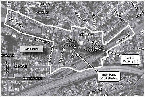
The draft Glen Park Community Plan (draft Community Plan) is a policy document that presents an overall concept for enhancing the existing neighborhood, as well as encouraging infill development at the BART parking lot north of the BART station and at the northwest intersection of Diamond Street and Bosworth Street.
The draft Community Plan proposes general design features and policies to guide future infrastructure improvements and update zoning (to a Glen Park Neighborhood Commercial Transit District [NCT]), design guidelines, and other City policies for future development. Design features and policies provided in the draft Community Plan address pedestrian safety, traffic flow, access to transit, parking and other transportation improvements.
The draft Community Plan also includes improvements to public spaces, such as improvements to the design and character of streets, redesign of the BART Station plaza, connecting public open spaces and greenways…
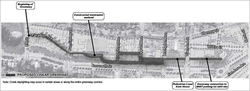
The proposed greenway (click to enlarge) “would consist of a linear open space running from Glen Canyon Park to downtown Glen Park located parallel to Bosworth Street, and would include a possible creek daylighting (bringing Islais Creek to the surface), creation of a storm water wetland, incorporation of walkways, and possible incorporation of bike lanes.” Yes, bike lanes (and racks downtown).
∙ Glen Park Community Plan: Initial Study [sf-planning.org]
∙ From Parking For Cars To Parking For People Across From GP BART [SocketSite]
Great plan which I’m sure is very helpful in the long run but an easy short term improvement would be to repave some of the major streets which are in horrific condition(e.g. Bosworth) and install better lighting underneath the San Jose Ave overpass. Simple maintenance is being neglected. Surely we can focus on the long and short term simultaneously!
This is actually pretty cool. The proposed greenway largely runs along the shortcut I take from BART to my son’s preschool. “The easement forms a “greenway” that is used by some members of the community as an informal open space.” – they must be referring to me. I’m not sure how the people living on Paradise will feel. This would limit car access to their homes if the street is closed to vehicles (I haven’t read the details). Most people will be more interested in the Plan’s impact to traffic in the Diamond/Boswarth/Chennery area which can be pretty ugly at commute times.
I like the looks of it. Gee, think this and the Cesar Chavez greening project have anything to do with Bernal and GP gentrification?
Love the trend of parks on top of highways (San Jose St.?) Hollywood Freeway is to be partially covered with a park, proposals for NYC’s BQ Expressway launched and I’m seeing the future. (And someday SF shall rethink our tangled miles of elevated highways running through increasingly residential SOMA and related ‘hoods. [80, 101, all those SUV lanes from Bayview up to the bridge including the 280 flying buttress by MBay]).
Our big dig will come one day and we’ll have amazing greenways for the next generation.
Invented: I’m hopeful San Jose avenue will be improved thereby connecting South Bernal and Glen Park but if the information in the community plan is anything to go by (see quote below) I suspect we are a long way off before anything substantial happens.
“Improvements that would occur beyond 2030 (e.g., converting San Jose
Avenue from a “freeway” to a City street) are considered speculative in nature and are not
included as part of the proposed project evaluated in this Initial Study.”
“Our big dig will come one day and we’ll have amazing greenways for the next generation.”
Then many more streets can become the hell that is 19th Ave! Woohoo!
But seriously, the current and present waterways of San Francisco have interesting histories. Check out what the area that is now 280/Alemany Blvd used to look like. There used to be two branches of Islais Creek that converged near the Mission Viaduct — one from Twin Peaks through Glen Canyon (which is what is running through Glen Canyon now), and one from near Top of the Hill-Daly City down Mission:
http://foundsf.org/index.php?title=Islais_Creek_Covered
“Then many more streets can become the hell that is 19th Ave! Woohoo!”
19th Ave – never … I envision much of 80 submerged with full parkland and bike lanes from potrero design center all the way to 5th stree. Next time your driving up there or suffering walking under the highway give it some thought. Flying 280 will be sunk as well.
It’s only a matter of time. (imo).
“I envision much of 80 submerged with full parkland and bike lanes…. […] Flying 280 will be sunk as well.”
For the kind of money the Big Dig took, I’d rather see BART down Geary (or even a restored B Geary-Ocean), a new Transbay Tube (with BART and CA HSR), and/or more subways in the city for the money.
Wouldn’t a Big Dig type undergrounding of major freeways cause (even more) serious problems in an earthquake (i.e., thousands of people potentially trapped underground)?
Actually if you were going to build something underground, the best place to start would something running under 19th Ave. from 280 to the GGB. Then car lanes could be removed from 19th ave. and bike lanes and greenery added. But I don’t think that will ever happen.
I would think it’s more likely to have BART under 19th Ave when the Geary line is finally built in 2050 after that merchant guy NoeValleyJim mentioned in the other thread dies. Much more likely than a freeway or car lanes or whatever under 19th.
So I live in Glen Park and have read the draft community plan. I think that most of the plan makes a lot of sense, in particular the bike lanes, improvements to the Diamond/Bosworth and Arlington/Bosworth intersections and improved bus access and flow around the BART station.
However, I doubt that the creek daylighting will go forward as it would involve removing garage access for a large number of homes on Paradise Ave and Chenery St. as well as demolishing as least one (and potentially several) homes. If you look at the map the “upper” greenway between Chilton and Lippard actually goes through my neighbor’s house. It would be much more economical to improve the already existing informal greenway (as well as Kern alley) from Diamond to the base of Paradise and forget about daylighting the creek.